
February half term is just around the corner. Check out our guide for a full round-up of events and activities.
Peak District Kids writer: Alice Wyatt
This short, circular Lumsdale Falls walk offers more than just a spectacular waterfall to see. There are peaceful ponds to relax by and the valley is oozing with history dating back to the 17th century, when the water-powered mills were all fuelled by Bentley Brook (the brook that feeds into Lumsdale Falls). The mills were used for cotton spinning and bleaching until the 1930s and what remains is a fascinating archaeological site with mill ruins, grinding stones and a wheel pit.
Although close to the bustling town of Matlock, this Lumsdale Falls walk is very peaceful. It can be completed in one hour if walking at a fast pace, but allow nearer to two hours if including snack breaks, exploring time and little legs (there’s a bit of a climb towards the end of the walk). There’s also a tap room and a pub just a little detour from the route, if you wanted to make more of a day of it.
Be warned, that during the winter months, some of the footpaths can get a rather slippy and very boggy, so wear decent footwear. Wellies are highly recommended!
PLEASE NOTE: As of February 2024, Lumsdale Valley is now open every day of the week (having temporarily been closed at weekends prior to this). Some areas are still cordoned off for the safety of visitors and for the preservation of the ruins. It is owned and maintained by the Arkwright Society.
Disclaimer: This post contains affiliate links. Should you click to purchase, it is at no additional cost to you, but I receive a small commission.
When planning your visit to the National Park, please arrive early or late in the day to avoid crowds if visiting over sunny weekends or school holidays. Please also take all litter home with you, don’t bring BBQs, and park your car in designated parking areas. Also, please use these walks as a guide; access and stiles may change.
PARKING INFORMATION: Please do not rely solely on the postcode for parking directions. In the National Park, a postcode can cover a large area. Postcodes are only provided as guidance. Please either use the Google Maps point or what3words, which are provided on every walk guide.
-

-
 My Walks Log Book£10.95
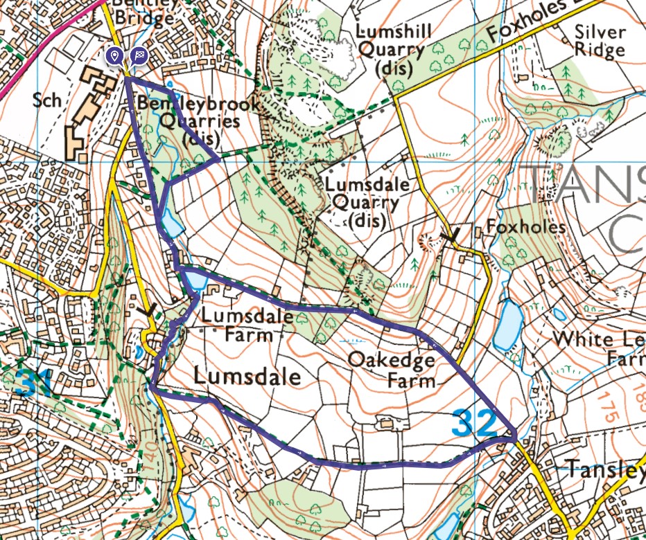
Lumsdale Falls map
On all Peak District family walks it’s a good idea to have an Ordnance Survey paper map with you, even if you have your phone on you. For this walk you need the OS Explorer Active Map OL 24 (White Peak). It’s also a good opportunity to show young kids the map features and get them started with map reading.
| Preview | Product | Price | |
|---|---|---|---|
|
The Peak District: White Peak Area Map | Weatherproof | Peak… | £12.34 | Buy on Amazon |
This Lumsdale Fall walk follows a clockwise direction.
Get a printable download of this walk
Want to print off this walk guide rather than rely on your mobile? Then click here to download the PDF to print out at home. Perhaps print out a copy for the kids to follow the step-by-step directions and/or photos? It’s a great way to get them engaged with the walk and gives them a sense of responsibility.
All printable downloads are £3 each. Click here for the full list of Peak District Kids printable downloads.
25% discount when you purchase 4 or more walk guides using code: PDKWALKS25
Please note that your download link expires 72 hours from order, so make sure you save your PDF somewhere where you’ll remember it. If you are unsure where your download folder is on your mobile device, we recommend you download the PDF on your laptop or desktop.
Need to know
DISTANCE OF WALK: 3.3km (2.1 miles)
TYPE OF WALK: circular walk with waterfalls, woodlands and views across the valley
PARKING: There is free on-street parking along Lumsdale Road, facing Highfield School. This may be a little busier on weekdays when the school is open (avoid school drop off and pick up times). Click here for Google Map point, postcode DE4 5LB.
PUBLIC TRANSPORT: The Matlock-Sheffield (some services extend to Wirskworth and Barnsley) bus (X17) and Matlock-Chesterfield bus (63) all stop at the junction of the A623 and Lumsdale Road.
WALK HIGHLIGHTS: Lumsdale waterfalls alongside the ivy-covered mill ruins, views to Riber Castle.
HOW LONG DOES IT TAKE: Without kids, this is a 1 hour walk. Allow over 2 hours with young kids and with time to explore around the falls.
ACCESSIBILTY: A few squeeze stiles, some muddy sections, and a steep hill towards the end.
TOTAL ASCENT: 109 metres
FACILITIES: There are no public toilets on this walk. Nearby eateries include the Bentley Bridge tap room (only open Friday evenings and weekends) and The Gate Inn (open every day) in Tansley village.

The route
START: Lumsdale Road
Click here for Google Map point
Grid reference: SK 3120 6118
Post code: DE4 5LB
what3words: ///hotels.into.palm
Route follows a clockwise direction.
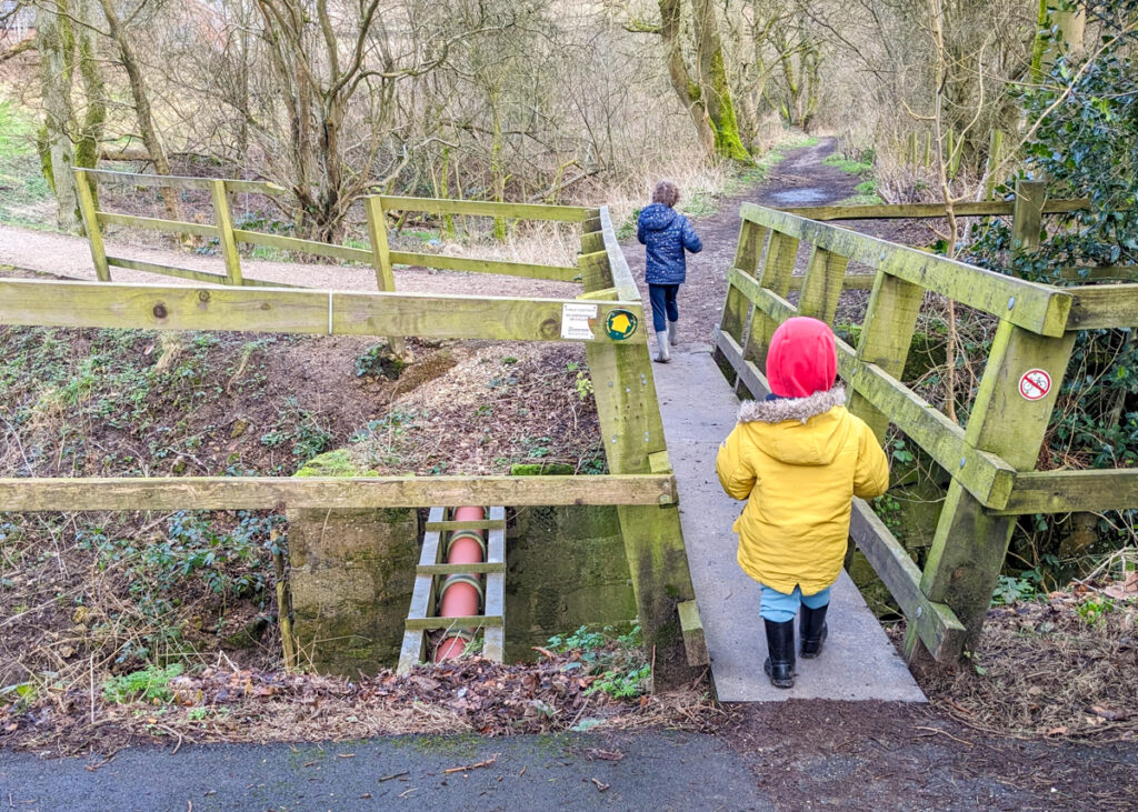
1. With the school on your right, walk along the pavement to the footpath sign on the left. Cross over the small bridge and continue along the path, straight ahead (not to the left).
2. After 300 metres you will reach the top of the path and will get your first view over the fields towards Riber Castle. Turn right here, and head down the path towards Lumsdale. This path is a little uneven so watch your step.

3. At the bottom, you will come to the stream with some handily-placed stepping stones to aid you across. The water lever can be high after wet weather, but you should still be able to cross (it’s honestly easier than it looks). On a warm summer’s day this is a lovely place for a cooling paddle.

4. When you get to the other side, turn left and follow the stream down towards the first pond, ‘Middle Pond’; a really calm spot where you might just see some interesting pondlife and birds. From here, re-join the path via the wooden steps and continue along the lane with the pond on your left, passing by a row of cottages. Cars do occasionally come down here, so take care.


5. At the end of the cottages you will see ‘Lower Pond’. There are a few benches that make for a welcoming snack stop. Once you have had a good explore (check out the view from the dam wall), follow the footpath to the right of the pond, past the 1983 stone to a stone stile.


6. The top entrance to Lumsdale Falls is currently closed, so you will need to climb over the stone stile and walk down the lane for 30 metres. There you will see steps on the left down to the open metal gate (also on the left) that leads you to Lumsdale Falls.


7. From here, you can explore all the sights and sounds of Lumsdale Falls. Please mindful of the drop and stick to the footpath to help preserve the area and the ruins. It is beautiful in every season, but it is impressive when the waterfall is in full force. The falls are surrounded by stunning ivy-covered ruins of the old mill buildings.


8. Continue weaving your way down the footpath, with the falls on your left.

9. At the bottom of the stepped footpath, walk through the wooden gate and out onto the quiet lane. Take a left and continue for 90 metres to the footpath sign that points left across the fields. Alternatively, a few minutes further down the lane is where you will find the Bentley Bridge Tap Room where you could pop for a quick refreshment. Be sure to re-trace your steps to continue this Lumsdale Falls walk.


10. Go through the squeeze stile and continue across the field, veering left, to another squeeze stile. Then continue along the footpath with the drystone wall immediately on your right. This footpath can get really boggy in wet weather. Continue across the fields passing through three wooden, kissing gates. There are sometimes some horses in one of these fields.


11. At the farm track, continue to the left to another squeeze stile. Here, you will merge onto the lane that leads down towards Tansley village.


12. 350 metres along the lane, turn left at the junction. Alternatively, you can turn right and five minutes up the road you will come to the large and popular pub, The Gate Inn. This offers food and drinks and also has a play area. It does get busy, so if you do want to eat there, it is best to book.

13. You will now begin an ascent up the lane, heading back towards Lumsdale Falls. Continue straight at the dead end sign, following the footpath sign. Along here you may spot llamas and some delightfully muddy pigs.


14. The path continues, passing along below the woods (ignore the public footpath sign on your right). Stay on this path for 400 metres, back to the ‘Lower Pond’. Then continue to the right, past Lumsdale cottages again, and back towards the ‘Middle Pond’.


15. From here you can continue going straight, sticking to the quiet road. This is a more direct route and will take you all the way back to Lumsdale Road, where you are parked, to complete this circular Lumsdale Falls walk.


Peak District Kids is a free online resource. If you have found this website useful for planning your family adventures, you can show your support by buying me a coffee. Thanks so much!

Also, feel free to share your walk photos in our Peak District Kids Facebook Group or on Instagram using by tagging @peakdistrictkids in your caption so we can share with our wider community.
-
-
My Walks Log Book£10.95
Want more ideas for family walks?
Best Family walks in the Peak District
Pram-friendly Peak District walks
Toddler walks in the Peak District
Walks with a baby carrier
Or, use the search walks page to find your perfect family walk.
Also, come and join our friendly Peak District Kids Facebook Group for any questions or to share photos of your walks.