Wondering what’s on over the summer holidays for families? Check out our What’s On guide.
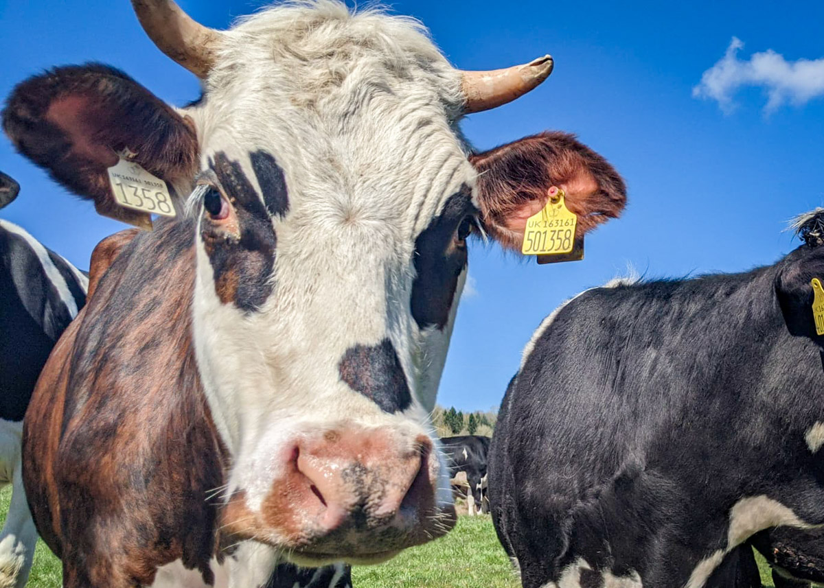
Are you nervous of bumping into cows on your Peak District walk? Here we share the best family walks in the Peak District where you are very unlikely to meet any cows.
The Peak District National Park is 86% farmland, which is used mostly for grazing sheep or cattle. This means that there’s a good chance that you will meet a herd of cows on your walk, especially if you are exploring the White Peak (southern half of the National Park).
Cows are big, inquisitive creatures and they do make some walkers nervous. Indeed, there have been cases of injuries and fatalities involving cows, although this tends involve walkers with dogs.
Understandably, you may want to avoid cows on your Peak District walk, especially if you have toddlers or a dog. So here we’ve hand picked the best cow-free Peak District walks from all the walks featured on this website for your peace of mind. Walks are listed in order of distance.
What to do if you meet cows on your walk
We cannot guarantee that you will not meet a cow on your walk. Land use changes, sometimes they escape from a field, and maybe you took a wrong turn.
If you do walk through a field of cows, walk calmly with confidence, and clap your hands as you ask them to move. A famer in the Peak District Kids Facebook group suggests saying, ‘come on girls, don’t block the path please’. If they do charge towards you, stand still and be calm. If you have a dog with you, let it off it’s lead.
However, if you don’t feel comfortable walking through a herd, farmers are absolutely fine with you walking around the edge of a field to avoid them, or perhaps taking a detour through another field.
Disclaimer: This post contains affiliate links. Should you click to purchase, it is at no additional cost to you, but I receive a small commission.
IMPORTANT READ: How to stay cool for your Peak District summer walks
When planning your visit to the National Park, please arrive early or late in the day to avoid crowds if visiting over sunny weekends or school holidays. Please also take all litter home with you, don’t bring BBQs, and park your car in designated parking areas. Also, please use these walks as a guide; access and stiles may change.
PARKING INFORMATION: Please do not rely solely on the postcode for parking directions. In the National Park, a postcode can cover a large area. Postcodes are only provided as guidance. Please either use the Google Maps point or what3words, which are provided on every walk guide.
Map of cow-free walks in the Peak District
Use the map below to see where our recommended cow-free walks in the Peak District are located.
Don’t leave home without your Peak District OS Map!
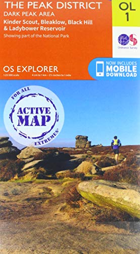
- For the northern half of the Peak District you will need the OS Dark Peak map. This covers Kinder Scout, Bleaklow, Black Hill and Ladybower Resevoir
- For the southern half of the Peak District you will need the OS White Peak map. This covers Buxton, Bakwell, Matlock and Dovedale.

1. Ox Stones – 1.7km
Ox Stones walk guide
Click here for start point
Printable download

Probably our favourite Peak District toddler walk, the easiest Peak District trig point walk, and our closest Peak District walk to Sheffield.
This short Ox Stones walk close to the Sheffield border is relatively flat, you can bag a trig point, the views are incredible, and there are rocks to climb. Plus there’s lots of wildlife to spot (caterpillars, butterflies, lizards, curlews and other ground nesting birds, hares and more!), and be sure to look across the landscape for deer, especially when on top of the rocks.
With the changing terrain this is a great walk for little ones to build core strength and balance. But please note that this walk is not pram friendly due to the rocky and uneven terrain.

2. Chatsworth Hunting Tower and Aqueduct – 2km
Chatsworth Hunting Tower and Aqueduct walk guide
Click here for start point
Printable download
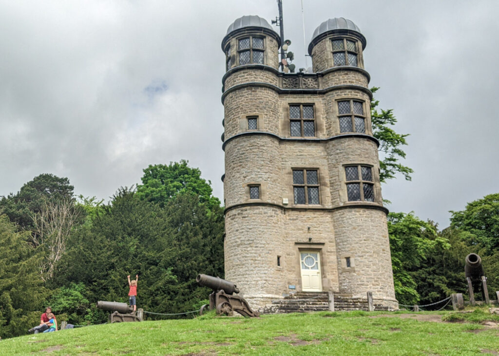
Standing proud over the Chatsworth Estate and on the edge of Stand Wood is the Chatsworth Hunting Tower, built in the 1570s. This high prospect tower can be seen for miles, and if your pockets are deep enough, you can even book to stay here! Then further along this walk is Sowter Stone Waterfall, which feeds down to the Chatsworth Aqueduct where four tall arches finish with another waterfall. It’s an impressive sight, especially in wet weather.
This really is a magical Peak District walk for kids (and adults!) as you weave through Stand Wood to visit these landmarks. The woodland itself can feel like a jungle in the summer months with it’s thick vegetation and abundance of bright flowers. And there are of course trees to climb! Plus, now and again, you get glimpses of Chatsworth House along the way.
It is free to walk around this section of the Chatsworth Estate, but you do need to pay for parking (£5). Parking payment is for a full day, so after this short Chatsworth Hunting Tower walk, you could visit the Farmyard and Adventure Playground, or the House and Gardens (tickets must be pre-booked online). Or head down to the river (which is free to do) for a picnic.
For this walk, not all the footpaths are marked on the OS Map; although Chatsworth allow visitors to walk along these footpaths. The below map is provided for guidance, but it’s probably best to follow the route description and photos below.

3. Snake Woodlands – 2.3km
Snake Woodlands walk guide
Click here for start point
Printable download

Snake Pass is one of the most spectacular roads in England offering expansive moorland views. But tucked half way along this route between Glossop and Ladybower Reservoir is a fairytale-like forest with a babbling brook, mossy stumps, and a beautiful waterfall to explore. This is Snake Woodlands, which hugs the banks of the River Ashop.
The short circular Snake Woodlands walk is a magical place for young kids to explore. Take a picnic and enjoy the serenity of this special place. Wellies may also be a good idea for the kids if they want to play in the river.

4. Birchen Edge – 2.6km
Birchen Edge walk guide
Click here for start point
Printable download
This is a great little Peak District pub walk for views and rocks to climb, and it starts at The Robin Hood pub, where kids eat free Monday to Friday! Plus there’s also the Birchen Edge trig point to bag en route.
Park in the pay and display car park next to the Robin Hood Inn (not in their actual car park, unless you’re stopping there for lunch), and walk up the road just for 20 metres, where you will see a footpath sign and gate that leads you to Birchen Edge.
We take the lower footpath first and after about 1km, before you see Nelson’s Monument on the hill top, you can climb up the rocks to the top. Or, there is a path if you don’t fancy the climb; just follow straight ahead. Once at the top, the views are fantastic and kids will love climbing up and over the big boulders.
Follow the footpath along the top of Birchen Edge to get back to the car park. There’s a steep descent right at the end, which can be quite slippy when wet. Take care.

5. Padley Gorge and Longshaw Estate – 2.7km
Padley Gorge walk guide
Click here for start point
Printable download
This Padley Gorge walk is one of our favourite Peak District family walks, especially for young kids, as they can paddle in the stream, climb boulders and trees, and there’s even ice-cream at the end! It’s a 2.7km circular walk that takes in the National Trust’s Longshaw Estate too (which is free to walk though). And even though it may seem a short distance, do allow a good three hours for this walk as there are so many places to play!
Don’t forget your cash for the ice-cream van. They don’t take cards.
If you want a shorter walk at Longshaw, we also have a specific walk just for toddlers. Check out our Longshaw walk for toddlers. Or if you’re after a longer Padley Gorge walk that’s more challenging for your kids, check out our Grindleford walk, which starts at Grindleford Station, and leads you up through Padley Gorge, and on to Owler Tor, Surprise View, Mother Cap, and Over Owler Tor.

6. Beeley and Hill Bank Plantation – 2.7km
Beeley and Hill Bank Plantation walk guide
Click here for start point
Printable download

Commonly referred to as Beeley Woods, Beeley and Hill Bank Plantation is a lovely place for a Peak District family walk. Forming part of the Chatsworth Estate, footpaths criss-cross through the woodland and a brook rushes down little waterfalls. We particularly enjoy it on a rainy day as the trees provide some shelter, and the sound of the rain on the tree tops is beautiful.
This is a short 2.7km walk around the Beeley and Hill Bank Plantation, but allow for a good few hours as the kids will love paddling in the stream and playing in the woods. Wellies during the winter months are a good idea, rather than hiking boots, so they can paddle.

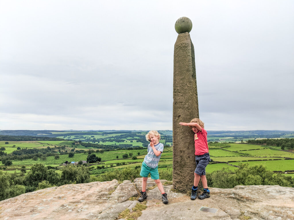
7. Stanton Moor (aka ‘The Cork Walk’ or ‘Nine Ladies Circle’) – 3.1 km
Stanton Moor walk guide
Click here for start point
Printable download


This short circular Stanton Moor walk has it all – unusual stones to explore, rocks to climb, woodland, open moorland views, muddy puddles, and Stanton Moor trig point! It’s easily one of our favourite family walks, and it’s a flat Peak District walk, which makes it easier on little legs and a good option for those with mobility issues (there are no stiles too).
At the start of the walk is a large rock that looks like a corkscrew; it’s begging to be climbed by the grownups if you’re up for the challenge. And half way around is a Bronze Age circle (the ‘Nine Ladies’) that was used by the Druids.

8. Curbar Edge short walk – 3.3km
Curbar Edge short walk guide
Click here for start point
Printable download

Curbar Edge offers some of the most impressive views in the Peak District and is best saved for a clear day (which also means that you should arrive early to get a parking spot). This short Curbar Edge walk leads you to the best viewpoints and returns via woodland that sits in front of the escarpment.
Whilst this walk is only 3.3km, allow a good couple of hours so that the kids can to play on the boulders and everyone can enjoy a hot chocolate overlooking the Derwent Valley. Just be mindful of the big drop and climbers on the escarpment face when playing on the boulders.

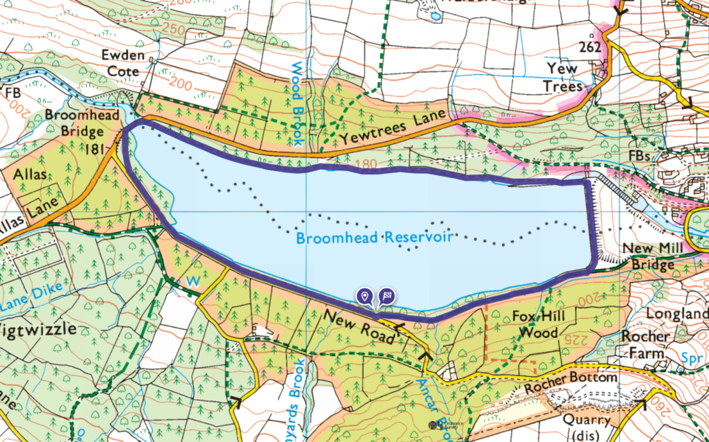
9. Broomhead Reservoir – 3.6km
Broomhead Reservoir walk guide
Click here for start point
Printable download

The Broomhead Reservoir walk sits within the South Yorkshire and Sheffield area of the Peak District National Park. With waves gently lapping at the shore and sandy secluded beaches to enjoy a picnic, this is a peaceful walk where you are gently reminded of the sea. It is one of the quieter Peak District reservoir walks, and the area commonly referred to as the ‘Mangrove’ (a tangle of knotted trees growing from within and beside the water) is an interesting places to climb and find fungi.
With it’s changing terrain, this is a fun walk for kids, but it’s also one of the best flat walks in the Peak District.
10. Valehouse Reservoir – 3.7km
Valehouse Reservoir walk guide
Click here for start point
Printable download

Situated on the Manchester edge of the Peak District National Park, this is an easy-going circular walk around Valehouse Reservoir that takes you over both Valehouse Reservoir Dam and Rhodeswood Reservoir Dam. There are interesting weirs and plug holes to spot enroute that help manage the flow of water along the reservoirs; Valehouse Reservoir is just one reservoir along a string of five in this region of the Peak District.
Much of the route is along paved lanes (some of which are accessed by very infrequent cars or tractors). This walk would be added to our list of Peak District pram-friendly walks, except the last section is along a very rocky path.
Please note that there is no direct access to the water along this Valehouse Reservoir walk, and swimming or paddling in the reservoir is strictly prohibited.

11. Longshaw Estate – 3.7km
Longshaw Estate walk guide
Click here for start point
Printable download

Longshaw Estate is a beautiful expanse of parkland, moors and ancient woodland, close to Padley Gorge. You’ll find yourself wanting to return again and again with so many different routes to try out. It’s great for kids with dens to play in, tree stumps to jump on, logs to balance on, and plenty of open space for them to burn some energy.
The flat, well-surfaced paths make for a perfect Peak District pram friendly walk. This is also a good walk option for the wetter months if you want to avoid the muddier walks.
Starting and finishing at the National Trust Wooden Pole car park, the walk follows the woodland path onto the open parkland. Allow some time for the kids to explore near the pond and play in Boggart Burrow.
Stop for a drink from the Croft Cabin or Longshaw Café before heading across the grassland back to the car park.

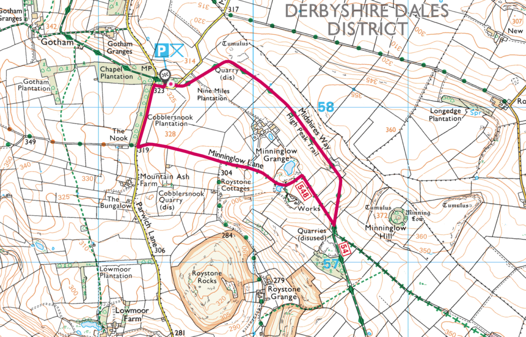
12. Minninglow – 3.8km
Minninglow walk guide
Click here for start point
Printable download

The High Peak Trail in the Derbyshire Peak District follows the old railway trackbed from Dowlow, near Buxton to Cromford. This circular Minninglow walk starts by following the trail at Minninglow, high up on the embankment before cutting through the hillside.
Kids will love playing in the old quarry and finding leftover sections of the railway track and machinery.
The second half of the walk leads you back to where you started, along another gentle track with drystone walls and open fields either side.
This route is flat with well-surfaced paths, so perfect for a Peak District pram friendly walk. It’s very easy going and often very quiet in this area of the National Park.
13. Mam Tor – 4.1km (or 1.1km if you’re just going to the summit and back)
Mam Tor walk guide
Click here for start point
Printable download

Mam Tor, meaning ‘Mother Hill’, is a 517 metre high hill overlooking Castleton and is one of the most popular family walks in the Peak District and the trig point is perhaps the most photographed trig point in the Peak District. The views from the top are spectacular, although arrive early during school holidays and weekends to avoid the crowds.
You don’t actually have to endure a long hike to get to Mam Tor trig point itself. If you park at this car park it is just a short (but steep) 550 metre walk uphill. Click here to read all about the quick and easy route to Mam Tor trig point.
Our 4.1km Mam Tor walk takes in the classic loop along Great Ridge and Broken Road. Starting at the Mam Tor National Trust car park it’s a short climb to the top of Mam Tor (517m). From here, the walk leads you down to Hollins Cross, and then down through the woodlands to meet Broken Road (which is a very broken road that was abandoned due to landslides in the 1970s). Following Broken Road the walk leads you up past the entrance to Blue Johns Cavern, before returning back to the car park.

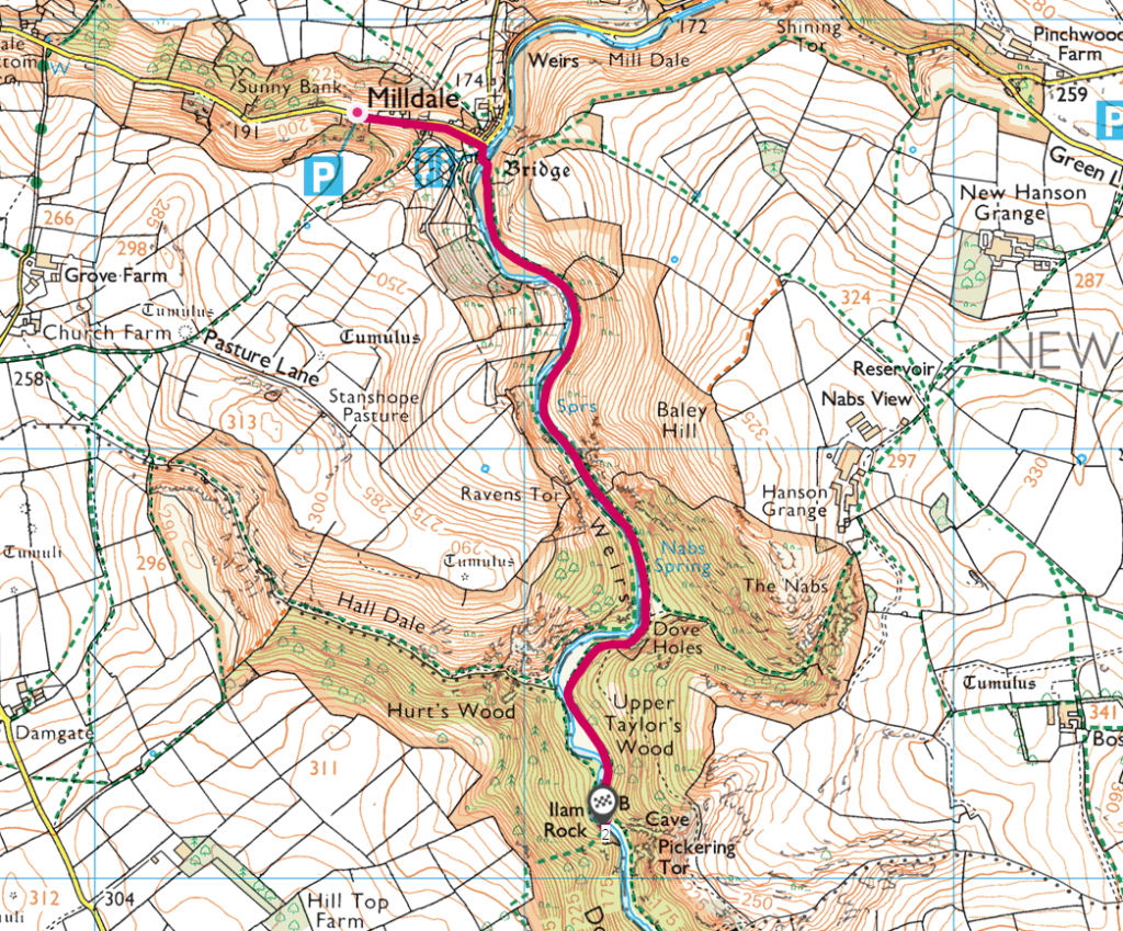
14. Milldale to to Ilam Rock – 4.5km
Milldale to to Ilam Rock walk guide
Click here for start point
Printable download

Dovedale is a very popular destination for walkers and most make a beeline for Dovedale Stepping Stones. But further up the valley lies the sleepy hamlet of Milldale where this classic Peak District river walk begins.
Following the the River Dove closely along the Dovedale Valley this linear routes leads you past the impressive caves at Dove Dale and onto Ilam Rock, a 25-metre tall limestone pinnacle. Kids will especially love exploring the huge caves at Dove Dale and it’s worth bringing a torch along for their adventures.
This has to be one of the prettiest pram-friendly Peak District walks. However, there are a few cobbly/rocky sections to navigate and some muscle is required. Most of the footpath is relatively even, but an all-terrain buggy is advised.
This is also a great walk in the wetter months when you want to avoid muddy footpaths.
15. Higger Tor – 4.5km
Higger Tor walk guide
Click here for start point
Printable download

This Higger Tor walk is all about the superb expansive views, so save this one for a clear day. When the clouds roll in, visibility makes navigation tricky, especially through the boggy section half way through. It’s also very exposed, so wear layers and bring appropriate clothing. And if you have kids who love climbing, there are boulders galore on this walk, so we suggest at least three hours for this walk to allow for Spiderman training.

16. Dale Dike Reservoir – 4.8km
Dale Dike walk guide
Click here for start point
Printable download

The Dale Dike Reservoir walk is another not-well-known Peak District reservoir walk. It oozes with calm and tranquillity as you amble through woodland and meadows following the water’s edge. Waves gently lap against the sandy shores, twisted old trees grow as close to the reservoir as possible, and the sky reflects upon the water; you can’t help but feel relaxed here. Plus, the surrounding fields with grazing cows, geese and sheep make this a really wonderful, diverse environment for a Peak District family walk.
Dale Dike Reservoir (also sometime spelt Dale Dyke Reservoir) was the site of the Great Sheffield Flood when the Dam failed in 1864 killing over 250 people. There is signage enroute with more information about this catastrophic event. Watch the below YouTube video to find out more before your visit.

17. Shutlingsloe – 4.8km
Shutlingsloe walk guide
Click here for start point
Printable download

Nicknamed the ‘Matterhorn of Cheshire‘ due to its similar shape to the Matterhorn in Switzerland, Shutlingsloe (506 metres) is a great starter hill for little legs and one of the best Peak District trig walks.
This linear Shutlingsloe walk, right on the edge of the Peak District border in Cheshire, with a steady ascent of 245 metres, is a rewarding Peak District family walk that takes in forests, a trig point, and incredible 360 degree views.
This is a walk that enables little ones to to feel like they have climbed a mountain to stand on top of the world! From the top of Shutlingsloe, you will see The Roaches, Shining Tor (the highest hill in Cheshire), Macclesfield, and even across to Wales on a very clear day.
But this Shutlingsloe walk isn’t just about the views. The start of this walk takes you through Macclesfield Forest, which is home to the native broad-leaved tree, but mostly contains pine trees. Lately, work has been ongoing to fell sections of the forest to replant the broad-leaved tree, to retain its natural heritage.
Also, the largest heronry (breeding ground for herons) in the Peak District can be found in Macclesfield Forest and it is also home to a number of other animals. If you are in the forest early in the morning, you may be able to spot badgers, weasels or even red deer.

18. Chee Dale – 5km
Chee Dale walk guide
Click here for start point
Printable download
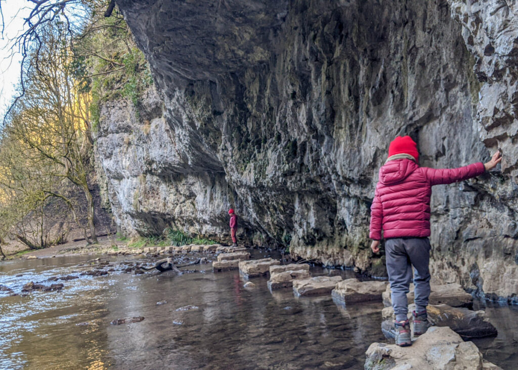
Sheltered beneath the Monsal Trail, is the peaceful nature reserve of Chee Dale where the River Wye meanders through a deep limestone gorge, and two sets of stepping stones provide access to walkers through the dale.
Our Chee Dale Stepping Stones walk starts from Millers Dale and leads you down into the verdant gorge where you need to navigate stepping stones along the limestone walls, before climbing back up to the Monsal Trail and walking through the long tunnels.
In heavy rain, the Chee Dale Stepping Stones are often submerged in water, so plan this walk for when the weather has been dry. Also, the footpath along the river is rocky and very uneven in places (with a couple of spots where you may need to slide on your bum), so those with little ones in a carrier may find it tricky in places.

19. Lud’s Church – 5.4km
Lud’s Church walk guide
Click here for start point
Printable download
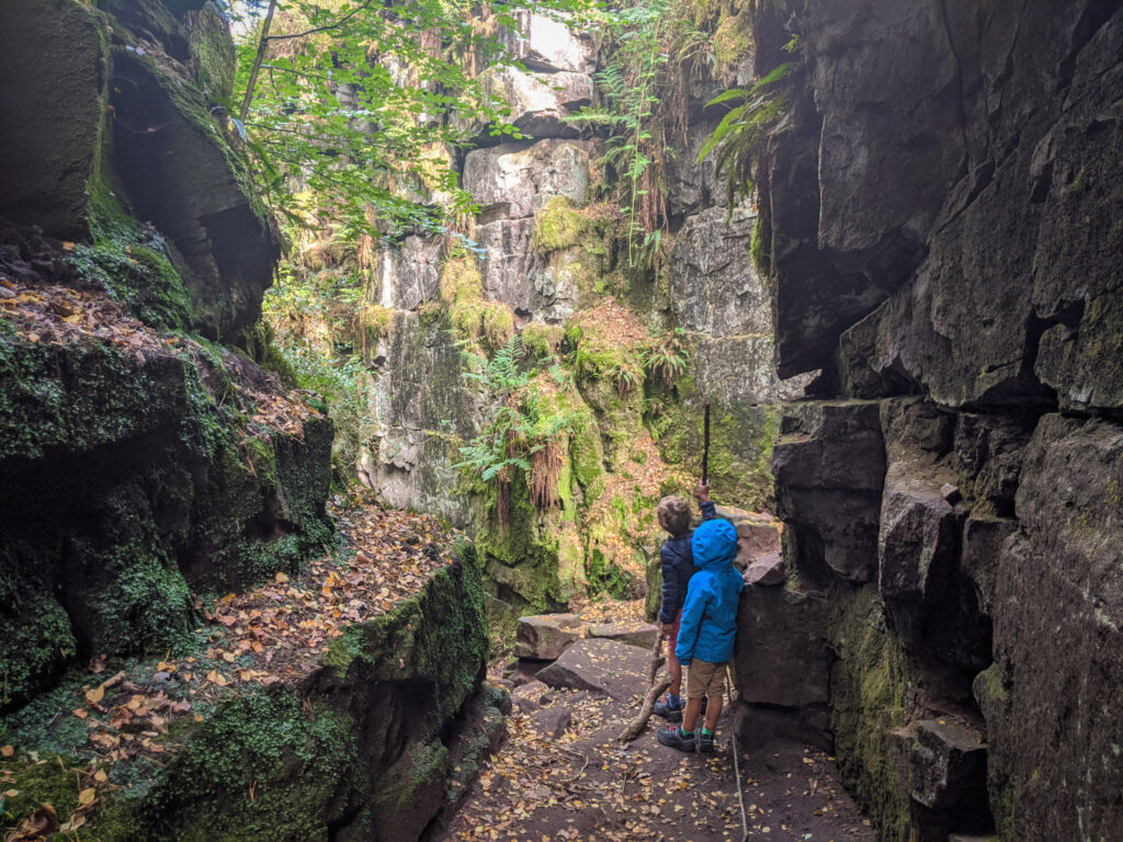
As you descend into the rocky depths of Lud’s Church, it feels like you’ve entered another world, away from the typical green rolling dales and farming land of the Peak District. Parents – this Lud’s Church walk is your opportunity to release your inner Indiana Jones… in Staffordshire. Created by a giant land-slip, this deep, moss-covered chasm is full of history and myths and makes for a fantastic family walk.
Lud’s Church is 18 metres deep and 100 metres long. Somehow trees have found a home on the dark, narrow cliff face and reach up for the light. And even though there is no steeple in site, it was used as a secret place for worship for people who would have otherwise been prosecuted in the fifteenth century. It’s also believed that Robin Hood and Friar Tuck once used it as a hiding place from the authorities.
Most visitors park at Gradbach car park and follow the 2.2km route to Lud’s Church and back (4.4km total). However, this route gets very busy on weekends and holidays, and the car park is often full by 9:30am (it’s also a good starting point for the Three Shires Head walk). Plus this route is mainly through woodland, and we always prefer a bit of variety on our walks with little ones.
Peak District Kid’s circular Lud’s Church walk begins at this road side parking near to the Roaches and quickly descends into forest to reach Lud’s Church. It then leads you back up on a gradual ascent with fantastic views over the Staffordshire countryside. You may want to combine this walk with our Roaches walk, detailed below.

20. Cressbrook Mill to Litton Mill – 5.5km
Cressbrook Mill to Litton Mill walk guide
Click here for start point
Printable download
Please note, whilst this is listed as a pram-friendly walk, this is one of the trickier ones. During and after wet weather, the footpath along the river can be very muddy. There are also two small sets of steps leading to an uphill and slightly rocky path to the Monsal Trail. It’s doable, just be prepared.

This pram friendly Peak District walk starts at Cressbrook Mill and follows the winding River Wye through the valley to Litton Mill and back along the Monsal Trail. The first half takes you through the steep-sided dale of Water-cum-Jolly with its impressive limestone crags. Whilst the second half loops you back along the trail overlooking the breathtaking valley and river you’ve just walked along. There’s also a couple of tunnels to walk through which the kids always love.
The route is buggy friendly, although there are two small sets of steps leading to an uphill and slightly rocky path to the Monsal Trail. The first section of the route by the river can also get quite muddy in wet weather. We managed fine with our Phil & Teds buggy but be prepared to get muddy wheels if it’s wet. The rest of the walk is flat with well-surfaced paths, so good for little legs.

21. Langsett Reservoir – 5.8km
Langsett Reservoir walk guide
Click here for start point
Printable download

Langsett Reservoir is a really special place bursting full of rare wildlife and offers one of the best Peak District reservoir walks. Indeed, this circular Langsett Reservoir walk takes you right around the entire reservoir.
Boasting stunning views across the moorlands and down to the glistening water of the reservoir, there is something really soul-filling about this place. Interesting history of the area weaves it’s way through the land as it was once used to practice the Normandy invasion, with old tracks and bullet scars to show for it, offering interesting imaginary conversation with kids along the route.
The changing terrain and environments on this Langsett Reservoir walk keeps everyone interested; from pretty ancient woodland with twisting tree roots and muddy paths, to open moorland between the heather and bilberry, to tall towering pine forest with cones to fill your pockets.

22. B29 ‘Overexposed’ crash site, Bleaklow – 6km
B29 ‘Overexposed’ crash site walk guide
Click here for start point
Printable download

On 3rd November 1948, a Boeing B-29 Superfortress (American bomber) called Overexposed crashed into the Peak District moorlands, near Higher Shelf Stones on Bleaklow. Part of the 16th Photographic Reconnaissance Squadron, used for military photography, the plane crashed due to a fatal navigation error in poor visibility. All thirteen crew members lost their lives. Much of the wreckage remains on the moors as a memorial and an official plaque has been erected.
Only attempt this walk on a clear day. Many of the footpaths over the moor between the Pennine Way and Higher Shelf Stones are unclear and there are multiple options. It can be rather disorientating and in poor visibility it is very easy to get lost. The boggy tracks add to the difficulty.
It is extremely exposed on this walk. On hot, sunny days there is no shade, in the winter months the temperature drops, and you can often experience four seasons in one day. Wear appropriate clothing, including sturdy footwear, and bring enough water.
This is also a very popular Peak District walk and parking is limited. Aim to arrive before 9:30am on weekend and holiday days to secure a parking spot. Do not park behind the double yellow lines, you will be ticketed.

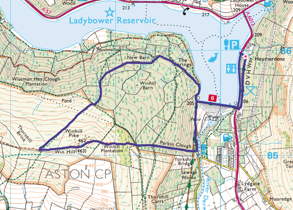
23. Win Hill – 6.2km
Win Hill walk guide
Click here for start point
Printable download

The views from Win Hill (462m) over Ladybower Reservoir and the Great Ridge in the Dark Peak are superb on a clear day. Whilst the direct route up to the summit is rather steep, this circular Win Hill walk allows for a steadier incline through the pine forest, more suitable young families. There is, however, a steep decline from the summit; whilst kids will probably bound down, parents may want to use walking poles, and it may be tricky for those with little ones in carriers.
This Win Hill walk is super fun, with woodland explorations, incredible views, boulders to scramble up to the summit, and a family snap at the Win Hill Trig point is a must! Starting from Heatherdene car park, this walk crosses over Ladybower Dam, meaning that you will also pass the Ladybower plugholes (technically known as shaft spillways), which drain water when the reservoir becomes full after heavy rains.
Make sure you have change for parking at Heatherdene car park (the machine doesn’t take cards). And on weekends and school holidays, arrive before 10am to get a parking space, as this car park does get exceptionally busy.
24. Shining Tor – 6.6km
Shining Tor walk guide
Click here for start point
Printable download

Shining Tor is the highest hill in Cheshire’s Peak District at 559 metres, yet this walk allows you to feel on top of the world without too much of an uphill challenge. Indeed, this is one of the best view walks in the Peak District. Just make sure you check the weather forecast before you go, as this is one you want to save for a clear day.
You can extend this walk and increase the ascent by starting lower down at Errwood Reservoir. However, this walk starts from the beautifully located Pym Chair car park at 461 metres, meaning you can reach the summit of Shining Tor fairly easily.
Completing the full Shining Tor walk rewards you with a trig point at summit along with fantastic views from the rocky outcrops along the ridge. You’ll be able to see the distinctive Shutlingsloe peak in the distance and on a clear day, you may even be able to make out the Wrekin in Shropshire, the mountains of Snowdonia in Wales and Jodrell Bank.

25. Robin Hood’s Cave walk along Stanage Edge to Stanage Pole- 6.9km
Robin Hood’s Cave walk walk guide
Click here for start point
Printable download

Hidden within the cliff face of Stanage Edge is Robin Hood’s Cave; a secret cave where the notorious Robin Hood and his merry men are believed to have taken shelter. Seeing that Little John is from Hathersage, this could be very true.
This walk guide tells you exactly how to find Robin Hood’s Cave, but also offers so much more; there are the boulders of Cowper Stone to play on and Stanage Edge trig point to bag. Plus, we extend the walk a little further to reach Stanage Pole, a large wooden pole that has stood for hundred of years, marking the border between South Yorkshire and Derbyshire, Hathersage and Sheffield, and probably the ancient kingdoms of Mercia and Northumbria.
Yes, it’s a linear walk, but there’s so much to keep the kids engaged. Plus this Robin Hood’s Cave walk mostly leads you alongside Stanage Edge and the views are utterly breath-taking on a clear day.

26. Stanage Edge – 7.7km
Stanage Edge walk guide
Click here for start point
Printable download

The Stanage Edge walk that takes in High Nebb trig point is all about taking in the superb views from arguably the most impressive gritstone escarpment in the Peak District. On a clear day, you can see across to Kinder Plateau and Mam Tor, with the angular summit of Win Hill protruding from the foreground, and further along this walk, you will get a glimpse of Ladybower Reservoir. Hathersage can also be easily spotted as Stanage Edge stands over this picturesque village. And for kids, there are LOTS of opportunities to play on the boulders (just keep an eye on them and make sure they don’t go too close to the edge!)
This Peak District family walk starts from Hollins Bank car park (at the base of Stanage Edge), which is just a short, steady climb to the top. You then follow the footpath along the top, passing High Nebb trig point, right to the end of the escarpment (aptly named Stanage End), before descending to the footpath below and following it all the way back to the car park.
Even on a warm summers day, it gets very blustery up on Stanage Edge, so take an extra layer with you. The footpath is also very uneven underfoot, so take care; kids will love playing ‘the floor is lava’.
Standage Edge features in the latest BBC adaptation of Pride & Prejudice (where Keira Knightly stood windswept and pensive over the landscape). And whilst we can’t guarantee you’ll find Mr Darcy on this walk, you will see lots of discarded millstones on the latter half of this walk, many still in tact from their industrial heyday.

27. Ladybower Reservoir – 9.1km
Ladybower Reservoir walk guide
Click here for start point
Printable download

From the Upper Derwent Visitor Centre is a lovely short stroll (300 metres) to Derwent Dam. When the water is overflowing, it’s a very impressive site.
Just before you reach Derwent Dam, there’s a little (buggy friendly) nature trail on the right through the woodland. Follow the nature trail around spotting the carved woodland creatures along the way, there are also picnic benches here. The full loop around the nature trail is only 400 metres. This is a perfect spot for a Peak District toddler walk.
If you want a longer walk, you can follow our pram friendly Ladybower Reservoir walk. This is a 9.1km loop around one half of the Y-shaped Ladybower Reservoir, with well-surfaced paths all the way round. Our clockwise route continues along the eastern side of the reservoir where the lost villages once stood before the area was flooded to create the reservoir. There are beautiful views all the way around but some of the best are from this part of the walk, looking across the water to the woods on the western side. Then after crossing over Ashopton Viaduct at the south end, the route follows the road back up the western side and then drops down onto the woodland path, returning back to the start.
The Ladybower Reservoir walk is probably the most popular reservoir walk in the Peak District.
There’s also a buggy friendly route all around Derwent Reservoir and Howden Reservoir (although note that cars are allowed on the road on the western side Monday to Friday). The full loop around is 16.8km.

-

-
 My Walks Log Book£10.95
 -
-

Peak District Kids is a free online resource. If you have found this website useful for planning your family adventures, you can show your support by buying me a coffee. Thanks so much!

Also, feel free to share your walk photos in our Peak District Kids Facebook Group or on Instagram using by tagging @peakdistrictkids in your caption so we can share with our wider community.
Want more ideas for family walks?
Best Family walks in the Peak District
Pram-friendly Peak District walks
Toddler walks in the Peak District
Walks with a baby carrier
Or, use the search walks page to find your perfect family walk.
Also, come and join our friendly Peak District Kids Facebook Group for any questions or to share photos of your walks.
