February half term is just around the corner. Check out our guide for a full round-up of events and activities.
This pram-friendly Peak District walk leads you along the even footpath of Thornhill Trail to Ladybower Reservoir, where you can see the two large Ladybower Plug holes (technically known as shaft spillways). With a diameter of 24 metres, these plugholes are very impressive in full flow when they allow the overflow of water in the reservoir to be drained through tunnels into the River Derwent.
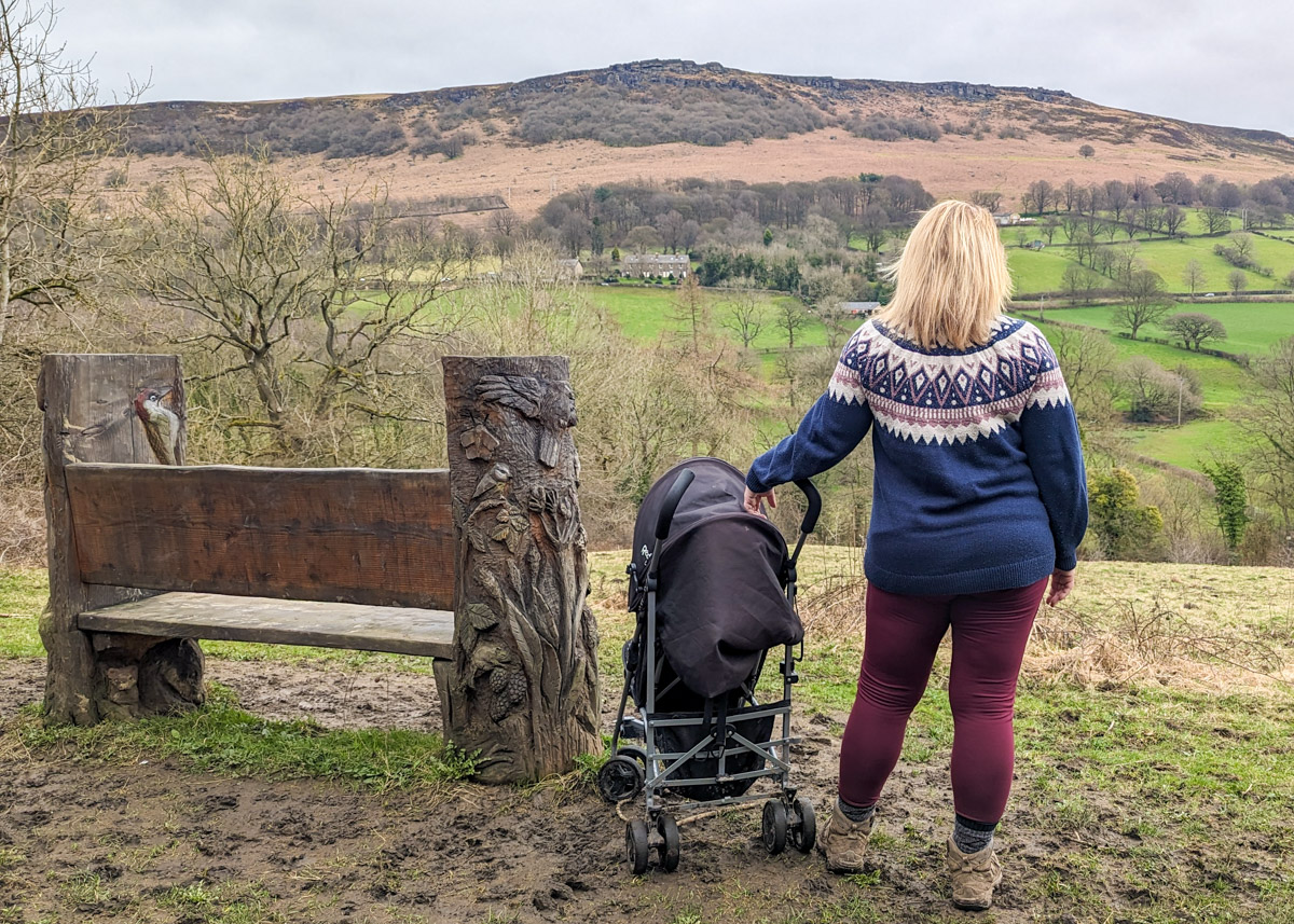
Little ones will enjoy spotting the carved animals along the Thornhill Trail, and a beautifully carved bench beckons you to sit for a snack with views across to Bamford Edge. Then after walking across Ladybower Dam, you may want to take a slight detour to the Yorkshire Bridge Inn for a pub lunch or local tipple (there are good veggie options as well as a kids menu). The walk then loops back through woodland, along quiet lanes, and back along the Thornhill Trail.
This walk starts and ends at Bamford with Thornhill Recreational Ground CIO (free parking), which has a lovely playground. However, if you would like to shorten the walk (3.7km), you can start from Carr Lane car park (also free parking), and start this walk at step 3. This will miss out a large section of the Thornhill Trail.
Disclaimer: This post contains affiliate links. Should you click to purchase, it is at no additional cost to you, but I receive a small commission.
When planning your visit to the National Park, please arrive early or late in the day to avoid crowds if visiting over sunny weekends or school holidays. Please also take all litter home with you, don’t bring BBQs, and park your car in designated parking areas. Also, please use these walks as a guide; access and stiles may change.
PARKING INFORMATION: Please do not rely solely on the postcode for parking directions. In the National Park, a postcode can cover a large area. Postcodes are only provided as guidance. Please either use the Google Maps point or what3words, which are provided on every walk guide.
-
-
 My Walks Log Book£10.95
Bamford pram-friendly walk map
On all Peak District family walks it’s a good idea to have an Ordnance Survey paper map with you, even if you have your phone on you. For this walk you need the OS Explorer Map OL 01 (Dark Peak). It’s also a good opportunity to show young kids the map features and get them started with map reading.
| Preview | Product | Price | |
|---|---|---|---|

|
The Peak District: Dark Peak Area | Weatherproof | Peak… | £14.99 | Buy on Amazon |

Get a printable download of this walk
Want to print off this walk guide rather than rely on your mobile? Then click here to download the PDF to print out at home. Perhaps print out a copy for the kids to follow the step-by-step directions and/or photos? It’s a great way to get them engaged with the walk and gives them a sense of responsibility.
All printable downloads are £3 each. Click here for the full list of Peak District Kids printable downloads.
25% discount when you purchase 4 or more walk guides using code: PDKWALKS25
Please note that your download link expires 72 hours from order, so make sure you save your PDF somewhere where you’ll remember it. If you are unsure where your download folder is on your mobile device, we recommend you download the PDF on your laptop or desktop.
Need to know
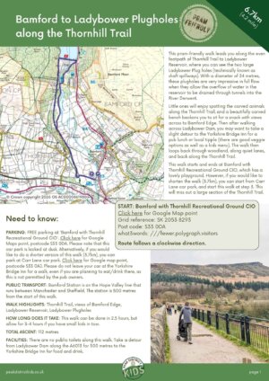
DISTANCE OF WALK: 6.7km (4.2 miles)
TYPE OF WALK: pram-friendly, circular
PARKING: Bamford with Thornhill Recreational Ground CIO. Click here for Google Maps point, postcode S33 0DA. Parking here is FREE, but please note that this car park is locked at dusk. Alternatively, if you would like to do a shorter version of this walk (3.7km), you can park at Carr Lane car park. Click here for Google map point, postcode S33 0AJ. Please do not leave your car at the Yorkshire Bridge Inn for a walk, even if you are planning to eat/drink there, as this is not permitted by the pub owners.
PUBLIC TRANSPORT: Bamford Station is on the Hope Valley line that runs between Manchester and Sheffield. The station is 500 metres from the start of this walk.
WALK HIGHLIGHTS: Thornhill Trail, views of Bamford Edge, Ladybower Reservoir, Ladybower Plugholes
HOW LONG DOES IT TAKE: This walk can be done in 2.5 hours, but allow for 3-4 hours if you have small kids in tow.
ACCESSIBILTY: Pram-friendly, relatively flat, well-surfaced paths.
TOTAL ASCENT: 112 metres
PUBLIC TOILETS: There are no public toilets along this walk. Take a detour from Ladybower Dam along the A6013 for 300 metres to the Yorkshire Bridge Inn for food and drink.


The route
START: Bamford with Thornhill Recreational Ground CIO
Click here for Google Map point
Grid reference: SK 2053 8293
Post code: S33 0DA
what3words: ///fewer.polygraph.visitors
Route follows a clockwise direction.
1. Take a left out of the car park and walk along Water Lane for 300 metres. Be mindful that the occasional car drives down here.

2. Follow the lane past the buildings and then just after the private parking for residents, the Thornhill Trail begins on the right. This is signposted ‘Yorkshire Bridge & Thornhill’.

3. Follow the Thornhill Trail for 2.7km to Ladybower Dam. After 1km, you will come across Carr Lane carpark. Cross the road just after the car park and continue along the trail. Along the way there are carved creatures to find, as well as a beautiful bench to perch and take in the views of Bamford Edge across the valley. At Ladybower Dam, you can continue walking straight ahead, keeping the reservoir on your right, to lengthen the walk if you wish. Do also take a moment to check out the first of the Ladybower Plug Holes. This is tucked in the left-hand corner of the dam.


4. To continue this walk, walk across Ladybower Dam. You will spot another plug hole in the opposite corner of the dam wall.

5. At the other side of Ladybower Dam, walk through the black railings on the right and follow the footpath downhill. However if you’ve planned a pub detour, instead follow the road for 350 metres to reach The Yorkshire Bridge Inn. After the pub, instead of backtracking to the dam, you could continue along the road for 350 metres and then take a right along Lydgate Lane and jump to step 7.


6. At the footpath junction, take a left. This leads you out onto Lydgate Lane.

7. Turn right at Lydgate Lane, walk over the bridge, and continue round to the left, onto Carr Lane. The River Derwent is on your left. Please be aware that cars do come along here occasionally. This leads back to Carr Lane car park. From here, re-join the Thornhill Trail and retrace your footsteps back to the car.


Peak District Kids is a free online resource. If you have found this website useful for planning your family adventures, you can show your support by buying me a coffee. Thanks so much!

Also, feel free to share your walk photos in our Peak District Kids Facebook Group or on Instagram using by tagging @peakdistrictkids in your caption so we can share with our wider community.
-
-
My Walks Log Book£10.95
Want more ideas for family walks?
Best Family walks in the Peak District
Pram-friendly Peak District walks
Toddler walks in the Peak District
Walks with a baby carrier
Or, use the search walks page to find your perfect family walk.
Also, come and join our friendly Peak District Kids Facebook Group for any questions or to share photos of your walks.