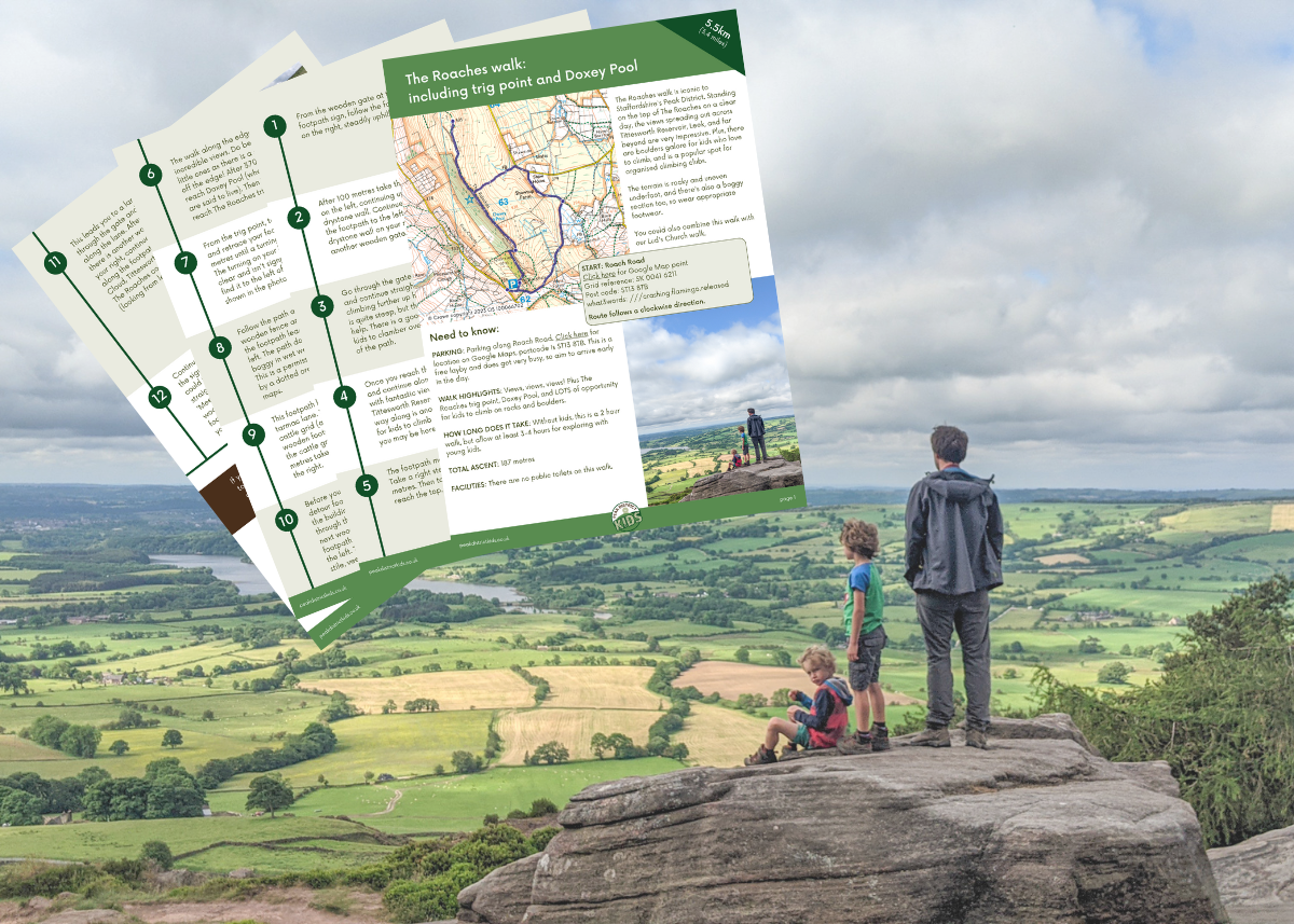
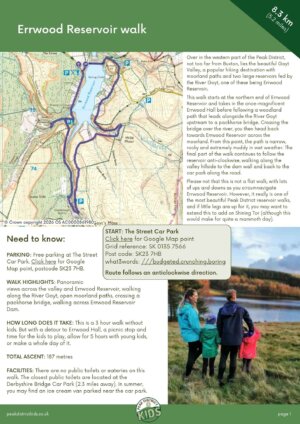
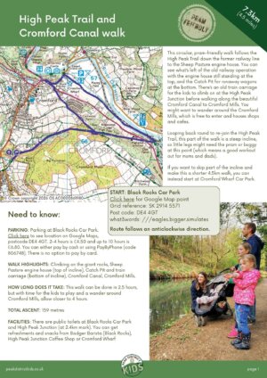
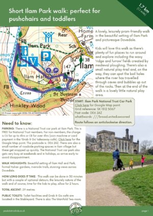
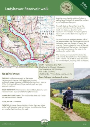
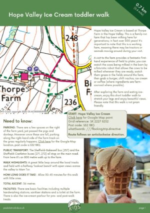
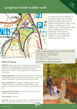
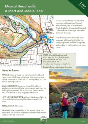
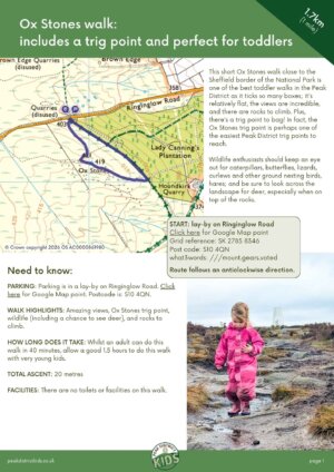
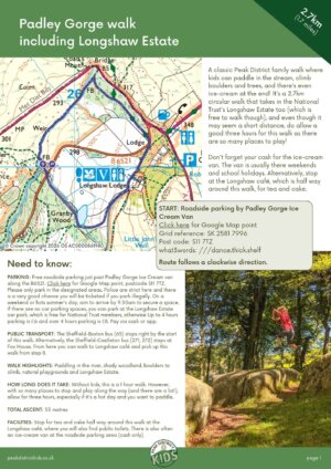
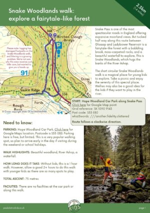
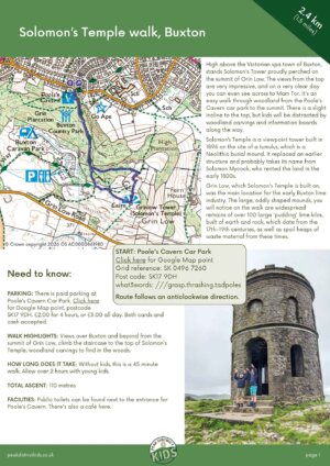
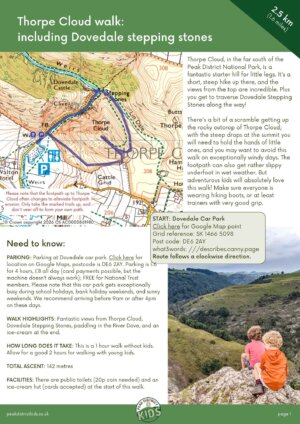
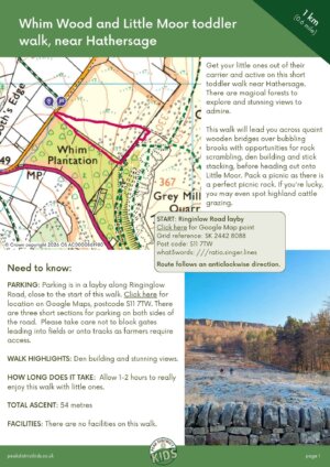
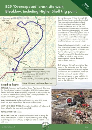
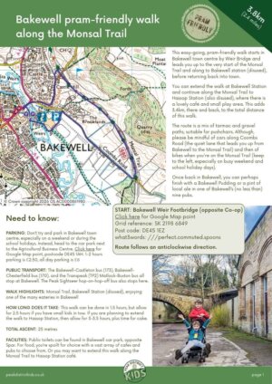
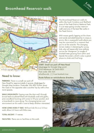
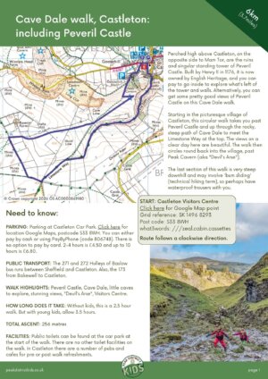
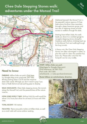
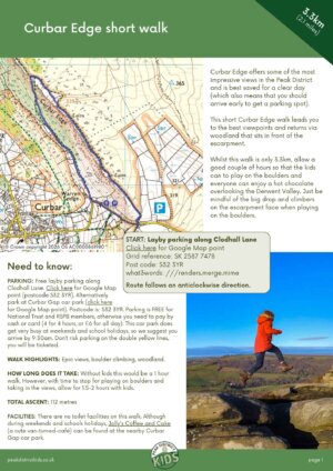
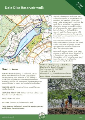
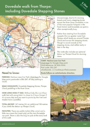
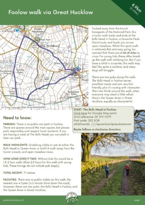
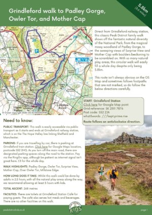
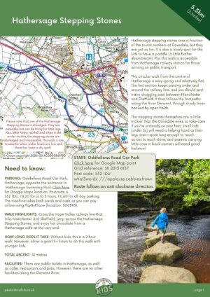
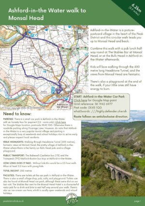
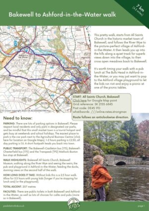
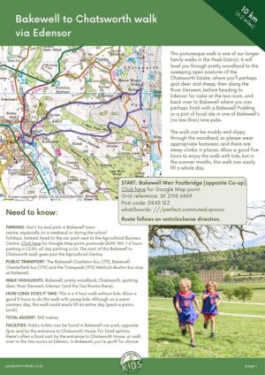
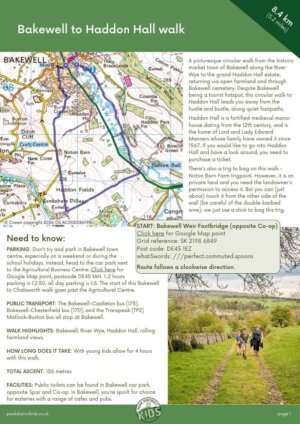
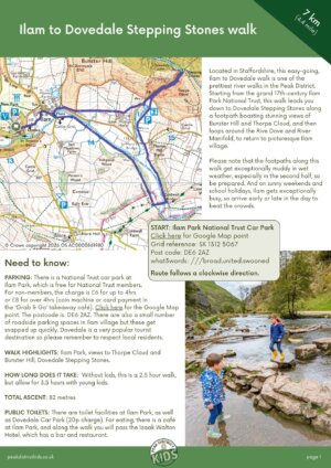
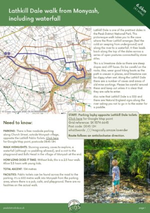
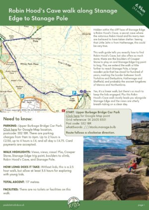
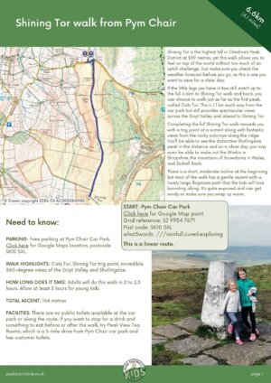
Every walk on the Peak District Kids website is available as a downloadable PDF. There are over 80 downloadable walk guides available, and these include all the main Peak District family walks, pram-friendly walks, and toddler walks. If you feel like there a lot of walks to choose from, then use our search walks page to search for your perfect family walk.
A PDF of each walk guide means that you don’t need to rely on your phone for our step-by-step directions, or perhaps you want to print out a copy for the kids to do their own navigation.
Each printable download is just £2.50, whether it’s a short 1km toddler stroll or an epic walk up Kinder Scout.
These printable guides are downloadable PDFs, which will be available to you offline and advert-free for your walks.
Once you have purchased, you will be able to download the PDF direct from the order confirmation page. If you are downloading onto your phone, ensure you know where your download file is. You will also be sent an email within 24 hours of your order with the link to download within 3 days. Your order permits only one download.
By purchasing this printable walking guide, you agree that it is for your own, personal use and it will not be copied and distributed elsewhere. Please email info@peakdistrictkids.co.uk if you would like to distribute this printable walking guide to multiple users for commercial use.
This article contains affiliate links. Should you click to purchase, it is at no additional cost to you, but I receive a small commission.

Join our
FB community
Join over 30,000 members
sharing ideas and tips
for exploring the
Peak District with kids.

SEARCH walks
There are over 80 walks
on this website. Search
for your perfect family
walk
Waterproof case
For print outs
If you plan to print out our guides to take out on a walk, we recommend putting the printouts in a waterproof map case that you can carry.
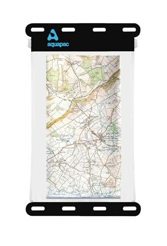
- 🌧️ WATER RESISTANT MAP PANEL: Withstand tough weather conditions to keep your maps dry during…
- 📏 FITS OS MAPS: Specially designed to accommodate OS maps, ensuring you have the right fit for…
- 🎒 FOLDABLE & EASY TO CARRY: Lightweight at 55g, the map case is foldable, and the adjustable…
- 📱 TOUCH SCREEN COMPATIBLE: Operate your electronic devices through the clear window, providing…
- 🔒 SECURE CLOSURE: Features a hook and loop opening/closure mechanism for easy access and added…
For reading pdfs on your phone
If you plan to follow the pdf walk guide on your phone, a waterproof case for your phone is recommended.
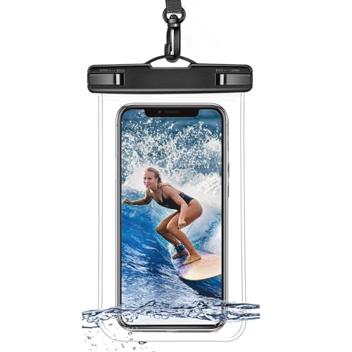
However, we do recommend having a battery pack to charge your phone should your battery die (phone batteries don’t do very well in cold environments) and having a paper print out as a back up.
- Never Run Out of Power: The 10,000mAh capacity enables this power bank to charge your iPhone 14…
- Dual Charging: The USB-C port supports two-way fast charging for added convenience.
- Extremely Safe to Use: With a fireproof casing*, high-density polymer cell, smart circuit, and…
- Simultaneous Charging: With the ability to charge two devices at once at up to 12W max, this power…
- What You Get: Anker 323 Power Bank (PowerCore PIQ), welcome guide, our worry-free 18-month warranty,…
Printable walking guides available
Our printable walking guide come as a downloadable PDF which will be available to you offline and advert-free for your walk.
Once you have purchased, you will be able to download the PDF direct from the order confirmation page. You will also be sent an email immediately with the link to download within 3 days.
Please note that your download link expires 72 hours from order. So make sure you save your pdf somewhere where you’ll remember it. If you are unsure where your download folder is on your mobile device, we recommend you download the PDF on your laptop or desktop.
By purchasing this printable walking guide, you agree that it is for your own, personal use and it will not be copied and distributed elsewhere. Please email info@peakdistrictkids.co.uk if you would like to distribute this printable walking guide to multiple users for commercial use.
Pram-friendly walks
-
Bamford pram-friendly walk to Ladybower Dam (printable download) – 6.7km£2.50
-
Carsington Water walk (printable download) – 12.3km£2.50
-
Chatsworth walk from Baslow to Edensor (printable download) – 5.8km£2.50
-
Cressbrook Mill to Litton Mill walk (printable download) – 5.5km£2.50
-
Damflask Reservoir walk (printable download) – 6.1km£2.50
-
Dovestone Reservoir walk (printable download) – 4.2km£2.50
-
Errwood Reservoir walk (printable download) – 8.3km£2.50
-
High Peak Trail and Cromford Canal walk (printable download) – 7.3km£2.50
-
Ilam Park walk (printable download) – 1.6km£2.50
-
Ladybower Reservoir walk (printable download) – 9.1km£2.50
-
Longshaw Estate pram-friendly walk (printable download) – 3.7km£2.50
-
Milldale walk to Ilam Rock (printable download) – 4.5km£2.50
-
Minninglow walk (printable download) – 3.8km£2.50
-
Slippery Stones walk (printable download) – 2.8km£2.50
-
Stand Wood walk at Chatsworth (printable download) – 5.7km£2.50
-
Tittesworth Reservoir toddler and pram friendly walk (printable download) – 2.8km£2.50
-
Wetton Mill walk (printable download) – 4.4km£2.50
0.7km to 3km family walks
-
Alport to Youlgreave walk (printable download) – 3km£2.50
-
Baslow Edge walk (printable download) – 2.7km£2.50
-
Beeley and Hill Bank Plantation walk (printable download) – 2.7km£2.50
-
Birchen Edge walk (printable download) – 2.6km£2.50
-
Blacka Moor walk (printable download) – 1.7km£2.50
-
Blaze Farm walk (printable download) – 1km£2.50
-
Chatsworth Hunting Tower and Aqueduct walk (printable download) – 2km£2.50
-
Cressbrook Dale walk (printable download) – 1.8km£2.50
-
Derwent Dam toddler walk (printable download) – 1.6km£2.50
-
Hope Valley Ice Cream toddler walk (printable download) – 0.7km£2.50
-
Ilam Park walk (printable download) – 1.6km£2.50
-
Longshaw Estate toddler walk (printable download) – 1km£2.50
-
Monsal Head walk (printable download) – 2.4km£2.50
-
Ox Stones walk (printable download) – 1.7km£2.50
-
Padley Gorge walk (printable download) – 2.7km£2.50
-
Snake Woodlands walk (printable download) – 2.3km£2.50
-
Solomon’s Temple walk (printable download) – 2.4km£2.50
-
Thorpe Cloud walk (printable download) – 2.5km£2.50
-
Tittesworth Reservoir toddler and pram friendly walk (printable download) – 2.8km£2.50
-
Whim Wood and Little Moor toddler walk (printable download) – 1km£2.50
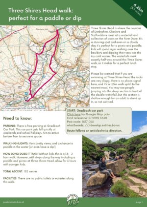
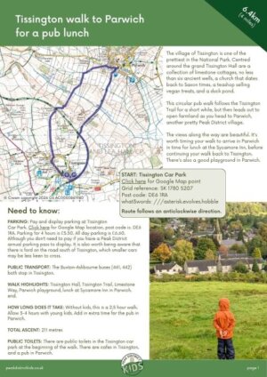
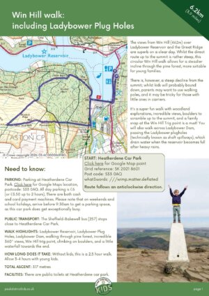
3km to 6km family walks
-
B29 ‘Overexposed’ crash site walk (printable download) – 6km£2.50
-
Bakewell pram-friendly walk (printable download) – 3.8km£2.50
-
Broomhead Reservoir walk (printable download) – 3.6km£2.50
-
Cave Dale walk (printable download) – 6km£2.50
-
Chee Dale Stepping Stones walk (printable download) – 5km£2.50
-
Curbar Edge short walk (printable download) – 3.3km£2.50
-
Dale Dike Reservoir walk (printable download) – 4.3km£2.50
-
Dovedale walk (printable download) – 5.3km£2.50
-
Foolow walk via Great Hucklow (printable download) – 4.9km£2.50
-
Grindleford walk (printable download) – 5.8km£2.50
-
Hartington walk to Beresford Dale caves (printable download) – 4.3km£2.50
-
Hathersage stepping stones walk (printable download) – 5.3km£2.50
-
Higger Tor walk (printable download) – 4.5km£2.50
-
Langsett Reservoir walk (printable download) – 5.8km£2.50
-
Little Barbrook walk (printable download) – 5km£2.50
-
Longnor walk (printable download) – 3km£2.50
-
Lud’s Church walk (printable download) – 5.3km£2.50
-
Lumsdale Falls walk (printable download) – 3.3km£2.50
-
Mam Tor walk (printable download) – 4.1km£2.50
-
Middleton to Youlgreave walk (printable download) – 3.6km£2.50
-
Over Haddon walk via Lathkill Dale (printable download) – 5km£2.50
-
Ramsden Reservoir walk (printable download) – 4.2km£2.50
-
Ramshaw Rocks walk (printable download) – 3.4km£2.50
-
River Derwent walk from Curbar to Froggatt (printable download) – 4km£2.50
-
Robin Hood’s Stride walk (printable download) – 3.1km£2.50
-
Shillito Woods and Ramsley Moor walk (printable download) – 4.4km£2.50
-
Shutlingsloe walk (printable download) – 4.8km£2.50
-
Stanage Pole walk (printable download) – 3.4km£2.50
-
Stanton Moor walk (printable download) – 3.1km£2.50
-
The Roaches walk (printable download) – 5.5km£2.50
-
Thor’s Cave walk from Wetton (printable download) – 5.6km£2.50
-
Valehouse Reservoir walk (printable download) – 3.7km£2.50
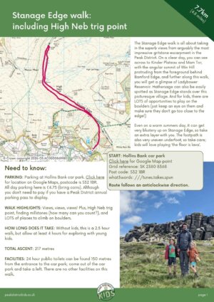
6km to 10km family walks
-
Ashford-in-the Water walk to Monsal Head (printable download) – 6.2km£2.50
-
Bakewell to Ashford-in-the-Water walk (printable download) – 7km£2.50
-
Bakewell to Chatsworth walk (printable download) – 10km£2.50
-
Bakewell to Haddon Hall walk (printable download) – 8.4km£2.50
-
Bamford Edge walk (printable download) – 7.9km£2.50
-
Curbar Edge walk (printable download) – 9.4km£2.50
-
Derwent Dam walk to Pike Low (printable download) – 6.8km£2.50
-
Errwood Reservoir walk (printable download) – 8.3km£2.50
-
Eyam Moor walk (printable download) – 6.3km£2.50
-
Lathkill Dale walk from Monyash (printable download) – 6.6km£2.50
-
Magpie Mine walk from Sheldon to Monyash (printable download) – 8km£2.50
-
Robin Hood’s Cave walk (printable download) – 6.9km£2.50
-
Shining Tor walk (printable download) – 6.3km£2.50
-
Stanage Edge walk (printable download) – 7.7km£2.50
-
Three Shires Head walk (printable download) – 6.2km£2.50
-
Tissington walk to Parwich (printable download) – 6.3km£2.50
-
Win Hill walk (printable download) – 6.2km£2.50
Kinder Scout walks
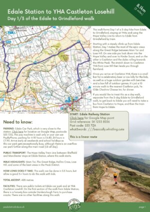
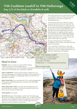
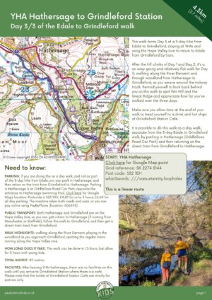
Multiday Peak District hike with kids
These walk guides form the three day Edale to Grindleford walk, staying at YHAs enroute.