
Wondering what’s on over the summer holidays for families? Check out our What’s On guide.
This YHA Castleton Losehill to YHA Hathersage walk forms Day 2 of a 3-day hike from Edale to Grindleford, staying at YHAs and using the Hope Valley Line to return to Edale from Grindleford by train. Head over to the Edale to Grindleford multi-day hike guide for a full overview, including kit list, meals, what you can expect at the YHAs, and other tips.
An easy-going start from Castleton to Hope warms you up for the climb up to Win Hill. The climb can be quite strenuous, so take your time to enjoy those views before bagging the trig at the top. The route then leads downhill to the Thornhill Trail to eventually meet up with the River Derwent. It’s a gentle amble along the river before braving the Hathersage Stepping Stones. From here it’s just a short walk into the village, where there are a range of cafes and pubs to refuel after your epic day.
Do check out our YHA Castleton Losehill review and YHA Hathersage review if you are planning to book.
This leg is the longest day of the Edale to Grindleford walk, so get an early start and have snacks at the ready.
If you would like to treat this as a day walk, separate from the 3-day Edale to Grindleford walk, the 271 and 272 Hulleys of Baslow bus runs between Hathersage and Castleton.
Disclaimer: This post contains affiliate links. Should you click to purchase, it is at no additional cost to you, but I receive a small commission.
IMPORTANT READ: How to stay cool for your Peak District summer walks
When planning your visit to the National Park, please arrive early or late in the day to avoid crowds if visiting over sunny weekends or school holidays. Please also take all litter home with you, don’t bring BBQs, and park your car in designated parking areas. Also, please use these walks as a guide; access and stiles may change.
PARKING INFORMATION: Please do not rely solely on the postcode for parking directions. In the National Park, a postcode can cover a large area. Postcodes are only provided as guidance. Please either use the Google Maps point or what3words, which are provided on every walk guide.
YHA Castleton Losehill to YHA Hathersage walk map
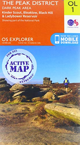
On all Peak District family walks it’s a good idea to have an Ordnance Survey paper map with you, even if you have your phone on you. For this walk you need the OS Explorer Map OL 01 (Dark Peak). It’s also a good opportunity to show young kids the map features and get them started with map reading.
| Preview | Product | Price | |
|---|---|---|---|
|
The Peak District: Dark Peak Area | Weatherproof | Peak… |
£13.55 |
Buy on Amazon |
This is a linear route.

Get a printable download of this walk
Want to print off this walk guide rather than rely on your mobile? Then click here to download the PDF to print out at home. Perhaps print out a copy for the kids to follow the step-by-step directions and/or photos? It’s a great way to get them engaged with the walk and gives them a sense of responsibility.
All printable downloads are £3 each. Click here for the full list of Peak District Kids printable downloads.
25% discount when you purchase 4 or more walk guides using code: PDKWALKS25
Please note that your download link expires 72 hours from order, so make sure you save your PDF somewhere where you’ll remember it. If you are unsure where your download folder is on your mobile device, we recommend you download the PDF on your laptop or desktop.
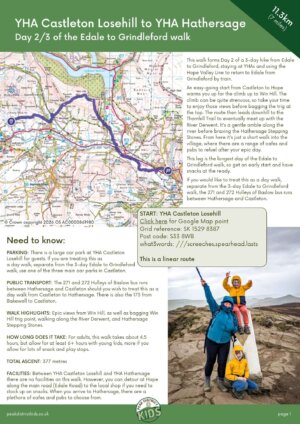
Need to know
DISTANCE OF WALK: 11.3km / 7 miles
TYPE OF WALK: Linear hill and river walk
PARKING: There is a large car park at YHA Castleton Losehill for guests. If you are treating this as a day walk, separate from the 3-day Edale to Grindleford walk, use one of the three main car parks in Castleton.
PUBLIC TRANSPORT: The 271 and 272 Hulleys of Baslow bus runs between Hathersage and Castleton should you wish to treat this as a day walk from Castleton to Hathersage. Click here for the timetable. There is also the 173 from Bakewell to Castleton.
WALK HIGHLIGHTS: Epic views from Win Hill, as well as bagging Win Hill trig point, walking along the River Derwent, and Hathersage Stepping Stones.
HOW LONG DOES IT TAKE: For adults, this walk takes about 4.5 hours, but allow for at least 6+ hours with young kids, more if you allow for lots of snack and play stops.
TOTAL ASCENT: 377 metres
FACILITIES: Between YHA Castleton Losehill and YHA Hathersage there are no facilities on this walk. However, you can detour at Hope along the main road (Edale Road) to the local shop if you need to stock up on snacks. When you arrive to Hathersage, there are a plethora of cafes and pubs to choose from.
The route
START: YHA Castleton Losehill
Click here for Google Map point
Grid reference: SK 1529 8387
Post code: S33 8WB
what3words: ///screeches.spearhead.lasts
This is a linear route.
1. From Castleton YHA, take the exit through the car park at the back and turn right down the lane, shortly passing a Camping and Caravanning site on your left.

2. When you reach a tarmac lane, take a left up to the stables. Then take a right, following the footpath sign that leads you alongside the stables.

3. Continue along the footpath, passing through a series of gates, following signs to ‘Hope’. This will take you over a railway line (this is a track for the quarry and not the main Hope Valley Line between Manchester and Sheffield).
4. 300 metres on from the bridge over the railway track, there is a footpath on your left, just after a gate. This is signposted ‘Edale Rd’. It’s easy to miss, so keep an eye out. Edale Road is just 70 metres along this footpath. If you need to stock up on snacks, take a right along Edale Road and walk into the village of Hope where there is a small local shop.


5. If you don’t need extra snacks, cross over the road and take the little lane downhill to the cottages immediately opposite. Ignore the footpaths leading off to the right and stay on this lane to walk under the railway line through an arch.


6. From the railway arch, take a right up the hill and follow this around to the left. Continue along the track that leads up to the farmhouses. This is a steady incline.

7. Walk through the farm buildings and follow the footpath on the other side of them.
8. Then the climb really begins! Walk uphill to the gate and continue diagonally left across the field. Make sure you look back at the views of the Great Ridge. The triangular peak of Win Hill will come into view as you walk uphill. Head directly to the summit to bag the trig point and take in the incredible views.
9. From Win Hill trig point, continue the footpath leading downhill on the other side. Take a right at the first drystone wall.


10. Continue straight ahead at the next drystone wall and follow the the footpath to a junction (this is not waymarked, but the footpath is obvious as it cuts through the heather). Take a left and then follow this downhill. At the second drystone wall take a right along the footpath. As long as you’re making your way toward Bamford (the village in the valley) you’re going in the right direction.

11. Ignore the footpath shortly on your right and continue the footpath to Thornhill for 1km. At the corner of a building is a turning left. Take this footpath and keep following signs to Thornhill.


12. This leads out to a road. Cross over and pick up the footpath the other side. Then walk the 40 metres downhill to the Thornhill Trail. Take a right at the trail and follow this to the very end for 670 metres.

13. When you reach the T-junction at the end of the trail, take a left. Then after 50 metres, climb over the stile on the right.
14. From the stile, follow the footpath down to the railway bridge on your right. Walk under, pass the sewage pumping station, and continue for 120 metres to the main road.
15. Carefully cross the main road and walk over the bridge on the other side. Just after the buildings on your left is a footpath. This will lead you over a footbridge. Then take the footpath on the left that follows the river.
16. Continue walking alongside the River Derwent for 1.9km to Hathersage Stepping Stones and cross over the river using the stepping stones. After heavy rain, these stepping stones may be submerged. If this is the case, you will have to continue along the footpath to the main road for 2.2km and then take a left along the main road into Hathersage. But if it looks safe to cross, go for it! If anyone does get wet feet, it’s not too far to the YHA to dry off.

17. Once across the stepping stones, take a right. After 380 metres, the footpath veers up to the left to meet the main road (A6187) into Hathersage.

18. At the main road, cross over to the pavement and take a right. Walk the 570 metres to YHA Hathersage. Reception doesn’t open until 5pm, so if you arrive early, we recommend popping into one of the pubs for a drink and perhaps a bite to eat.

-

-
 My Walks Log Book£10.95
 -
-

Peak District Kids is a free online resource. If you have found this website useful for planning your family adventures, you can show your support by buying me a coffee. Thanks so much!

Also, feel free to share your walk photos in our Peak District Kids Facebook Group or on Instagram using by tagging @peakdistrictkids in your caption so we can share with our wider community.
Want more ideas for family walks?
Best Family walks in the Peak District
Pram-friendly Peak District walks
Toddler walks in the Peak District
Walks with a baby carrier
Or, use the search walks page to find your perfect family walk.
Also, come and join our friendly Peak District Kids Facebook Group for any questions or to share photos of your walks.
