
February half term is just around the corner. Check out our guide for a full round-up of events and activities.
This YHA Hathersage to Grindleford Station walk forms Day 3 of a 3-day hike from Edale to Grindleford, staying at YHAs and using the Hope Valley Line to return to Edale from Grindleford by train. Head over to the Edale to Grindleford multi-day hike guide for a full overview, including kit list, meals, what you can expect at the YHAs, and other tips.
After the hill climbs of Day 1 and Day 2, it’s a an easy-going and relatively flat walk for Day 3; walking along the River Derwent and through woodland from Hathersage to Grindleford, as you weave around the railway track. Remind yourself to look back behind you on this walk to spot Win Hill and the Great Ridge and appreciate how far you’ve walked over the three days.
Make sure you allow time to treat yourself to a drink and hot chips at Grindleford Station Café.
It is possible to do this walk as a day walk, separate from the 3-day Edale to Grindleford walk, by parking in Hathersage (Oddfellows Road Car Park) and then returning on the direct train from Grindleford to Hathersage.
Disclaimer: This post contains affiliate links. Should you click to purchase, it is at no additional cost to you, but I receive a small commission.
When planning your visit to the National Park, please arrive early or late in the day to avoid crowds if visiting over sunny weekends or school holidays. Please also take all litter home with you, don’t bring BBQs, and park your car in designated parking areas. Also, please use these walks as a guide; access and stiles may change.
PARKING INFORMATION: Please do not rely solely on the postcode for parking directions. In the National Park, a postcode can cover a large area. Postcodes are only provided as guidance. Please either use the Google Maps point or what3words, which are provided on every walk guide.
-
-
 My Walks Log Book£10.95
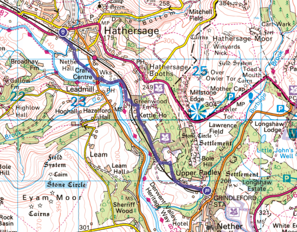
YHA Hathersage to Grindleford Station walk Map
On all Peak District family walks it’s a good idea to have an Ordnance Survey paper map with you, even if you have your phone on you. For this walk you need the OS Explorer Map OL 01 (Dark Peak). It’s also a good opportunity to show young kids the map features and get them started with map reading.
| Preview | Product | Price | |
|---|---|---|---|

|
The Peak District: Dark Peak Area | Weatherproof | Peak… | £14.99 | Buy on Amazon |
This walk follows a linear route from Hathersage to Grindleford.
Get a printable download of this walk
Want to print off this walk guide rather than rely on your mobile? Then click here to download the PDF to print out at home. Perhaps print out a copy for the kids to follow the step-by-step directions and/or photos? It’s a great way to get them engaged with the walk and gives them a sense of responsibility.
All printable downloads are £3 each. Click here for the full list of Peak District Kids printable downloads.
25% discount when you purchase 4 or more walk guides using code: PDKWALKS25
Please note that your download link expires 72 hours from order, so make sure you save your PDF somewhere where you’ll remember it. If you are unsure where your download folder is on your mobile device, we recommend you download the PDF on your laptop or desktop.
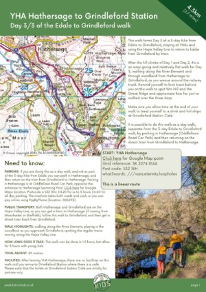
Need to know
DISTANCE OF WALK: 4.3km / 2.7 miles
TYPE OF WALK: linear river and woodland walk
PARKING: If you are doing this as a day walk, and not as part of the 3-day hike from Edale, you can park in Hathersage, and then return on the train from Grindleford to Hathersage. Parking in Hathersage is at Oddfellows Road Car Park, opposite the entrance to Hathersage Swimming Pool. Click here for Google Maps location. Postcode is S32 1DU. £4.20 for us to 3 hours, £6.60 for all day parking. The machine takes both cards and cash, or you can pay online using PayByPhone (location: 806393).
PUBLIC TRANSPORT: Both Hathersage and Grindleford are on the Hope Valley Line, so you can get a train to Hathersage (if coming from Manchester or Sheffield), follow this walk to Grindleford, and then get a direct train back from Grindleford.
WALK HIGHLIGHTS: walking along the River Derwent, playing in the woodland as you approach Grindleford, spotting the regular trains running along the Hope Valley Line.
HOW LONG DOES IT TAKE: This walk can be done in 1.5 hours, but allow for 3 hours with young kids.
TOTAL ASCENT: 89 metres
FACILITIES: After leaving YHA Hathersage, there are no facilities on this walk until you arrive to Grindleford Station where there is a café. Please note that the toilets at Grindleford Station Café are strictly for patrons only.
The route
START: YHA Hathersage
Click here for Google Map point
Grid reference: SK 2274 8144
Post code: S32 1EH
what3words: ///vans.eternity.loopholes
This is a linear route.
1. Take a right out of YHA Hathersage and walk along the road. Just after walking underneath the railway bridge, there is a footpath on your left through a wooden gate.


2. Walk through to the field and then across to the far corner. Look out for the trains along the railway track that run over a small weir to your left.


3. This leads out to a lane. Take a right and follow the bend around to the left. After you have passed the house on your right, take the footpath on the right, leading off from the lane.
4. Follow this footpath for 670 metres to the main road. Then cross the main road to pick up the footpath straight in front of you.

5. Follow this to the River Derwent and continue along this footpath for 730 metres.

6. At the footpath sign next to the drystone wall shown below, take a left behind the wall. Follow this slightly uphill (take in the views of Win Hill behind you) to walk under the railway arch.


7. Just 50 metres from the railway arch, there is a footpath junction. Take a right and follow the yellow arrows, passing an old barn on your right, and then into the woodland.
8. Continue through the woodland for 1km from railway arch. When you reach a point where the footpath splits (veering left one way, and crossing the railway track to the right), take the footpath veering left. This leads up to a wooden gate.
9. Walk through the gate and take the footpath to the right. This meets a cattle grid, which marks the top of the lane leading down to Grindleford Station. Follow this lane for 770 metres downhill to complete this Hathersage to Grindleford Station leg and Day 3 of the Edale to Grindleford walk.


Peak District Kids is a free online resource. If you have found this website useful for planning your family adventures, you can show your support by buying me a coffee. Thanks so much!

Also, feel free to share your walk photos in our Peak District Kids Facebook Group or on Instagram using by tagging @peakdistrictkids in your caption so we can share with our wider community.
-
-
My Walks Log Book£10.95
Want more ideas for family walks?
Best Family walks in the Peak District
Pram-friendly Peak District walks
Toddler walks in the Peak District
Walks with a baby carrier
Or, use the search walks page to find your perfect family walk.
Also, come and join our friendly Peak District Kids Facebook Group for any questions or to share photos of your walks.